
Press Release
Natural Resources Conservation Service
Colorado State Office
Denver Federal Center
Bldg. 56 Room 2604
PO Box 25426
Denver, CO 80225-0426
Web: https://www.co.nrcs.usda.gov
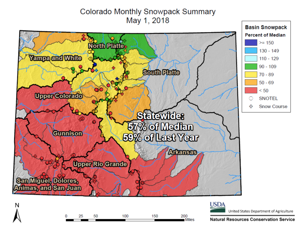
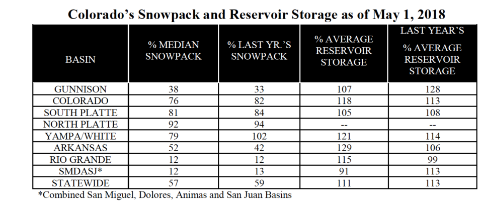
Denver, CO – May 4th, 2018 – In a given year, more than half of Colorado’s annual water supply comes from seasonal mountain snowmelt. “Maximum snowpack each year is an important factor in how much water individual basins might expect because as this snow melts it drives the highest river flows of the year and a substantial portion of total annual streamflow” says Brian Domonkos, Colorado Snow Survey Supervisor. Maximum snowpack values, otherwise known as peak snowpack, were mostly below to well below normal this year. The South Platte snowpack this year peaked near 90 percent of normal while the Upper Rio Grande and the combined Southwestern Colorado basins’ snowpacks peaked near 50 percent of normal. While peak timing was near normal this year at various points in April, since then nearly all mountain snowpacks have started to melt. April temperatures and lack of precipitation caused steep snowpack declines specifically in the Rio Grande and combined Southwest basins bringing snowpack to 12 percent of median on May 1. The situation is somewhat better in northern Colorado where snowpack is generally between 76 and 92 percent of normal. In between, the Gunnison river basin is at 38 percent of normal snowpack. Statewide snowpack also fell from 68 percent of normal last month to 57 percent this month.
Weather patterns typical of a La Niña year continue to deprive the southern half of Colorado of normal precipitation while allowing near to slightly below normal precipitation for the northern half of Colorado. According to mountain SNOw TELemetery (SNOTEL) stations, areas showing the greatest shortages occurred in the combined San Miguel, Dolores Animas & San Juan basins with a recorded 38 percent of average monthly precipitation this April and the Upper Rio Grande with 43 percent of normal. In stark contrast to the southern basins, near normal precipitation occurred in the northern reaches of the state including the Colorado, South Platte, & combined Yampa, White & North Platte basins, where month-to-date precipitation was 107, 94, and 98 percent of normal respectively. The Gunnison basin was on the more favorable side of the storm patterns this month receiving 78 percent of normal month-to-date precipitation, which compared to other months proved to be the second best month since the start of the water year, second only to the month of February with 107 percent of average precipitation. Below normal snowpack peaks combined with a shortage in recent precipitation across most of the state means many watersheds in Colorado will see below normal streamflows this summer. Nowhere in the state is the low snowpack more evident than the southern half where many rivers are forecast below 50 percent of normal.
For more detailed information about May 1 mountain snowpack and streamflow forecasts refer to the May 1, 2018 Colorado Water Supply Outlook Report. For the most up to date information about Colorado snowpack and supporting water supply related information, refer to the Colorado Snow Survey website. Or contact Brian Domonkos – Brian.Domonkos@co.usda.gov – 720-544-2852.


