

(YAMPA, Colo.) August 1, 2018 – The Silver Creek Fire made a push to the south and east on Tuesday, July 31 and is now 781 acres in size. Previously the fire had been under 200 acres. Fire managers have been expecting a run of this size at some point and preparations have been made. Most notably fuels
treatment prep work was done along Forest Road 100 (Buffalo Park Road) so it can be used as a fire break.
The fire has now reached the 100 Road and fire personnel are actively engaging it where it is safe to do so. Over 60 personnel are now working the fire, with more on the way.
The nearest structures to the fire are approximately four miles to the southeast at Latigo Ranch in Grand County, Colo. and are not immediately at risk. Old Park community is another couple miles past Latigo Ranch to the southeast.
Although there is no immediate threat, residents of Grand County are encouraged to enroll with the county’s alert system, so that if evacuations were to be necessary, emergency managers could quickly distribute that information.
• Grand County Code Red Alert sign up: https://public.coderedweb.com/CNE/en-US/8353F1C0B3BC
• Grand County Office of Emergency Management: https://gcemergency.com/
A smoke monitor has been set up in the town of Kremmling, Colo. to keep tabs on air quality during the Silver Creek Fire.
Broadly, the fire is still well within the area of expected expansion. It is now in both Routt and Grand Counties, as well as on the Routt and Arapaho National Forests.
A wildfire module from the Black Hills (Type III) has assumed command of the fire, with Lee Duekeras the Incident Commander.
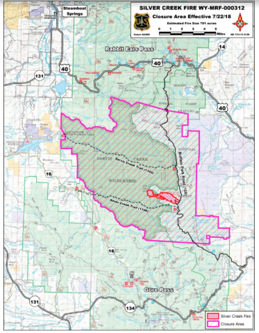
Silver Creek Fire was reported Thursday, July 19, near the peak of Gore Mountain in the Sarvis Creek Wilderness and on the Routt National Forest. The blaze was burning in mixed conifer, which includes lodgepole pine, spruce, fir, and both live and bug-killed timber.
Fire managers are implementing a full suppression strategy to fight the fire and will take direct actions where it is effective and safe to do so, with the highest probability of success. At its’ origin, access is difficult and firefighters were not able to safely fight the fire due to hazard trees.
The fire origin is approximately 10 miles north of Gore Pass and Colorado Highway 134.
An area closure has been implemented by the U.S. Forest Service for the immediate fire area and additional National Forest lands that could be impacted by the fire. All of Sarvis Creek Wilderness is closed and National Forest System lands immediately to the east, including a portion of the 100 Road.
Silver Creek Fire information and updates will be provided by the U.S. Forest Service on Twitter,
@FS_MBRTB, and on InciWeb, https://inciweb.nwcg.gov/incident/5985/.
Additional news releases will be issued as determined by fire behavior and public impact.


